Start: Mile 1498.7, Elevation 2157 feet – Off trail in Dunsmuir
Finish: Mile 1523.0, Elevation 6496 feet – Campsite on ridge overlooking lake and Mt. Shasta
Total mileage (including detours): 25
Total elevation: Gain +6749 / Loss -2410 / Net +4339
When I hopped off the train in Dunsmuir this morning at 6:30 a.m., I was eager to get back on the trail and surround myself with high mountain peaks and tall trees. It quickly became apparent, though, that while I might be mentally ready, my body had not kept pace with my mind. After two weeks with little exercise and living a city life, my muscle memory had faded, and I had begun to forget the routines I established.
My day started with a walk through the sleepy and quaint town of Dunsmuir, nestled between two pine-laden hills. As I climbed out of the train station, I passed several little coffee shops, the requisite tourist T-shirt shop, and a hop garden next to a brewery. At a bus station, I ran into Dan, an older man with long white hair circling a bald spot and a necklace who went by the name Dirty Face. A self-described “train tramp,” he was on his way toward Black Butte near Shasta for a music festival. Sporting a dusty green pack with a bedroll tied on top, he advised me that I might be able to get to the PCT trailhead five miles south by following the Amtrak rails, but I’d have to watch out for “the bull” – meaning the guy that guards the train tracks from trespassers. He also told me a few more stories about riding boxcars in his youth before I took off north to the junction with Interstate 5, where I hoped to catch a ride.
There I ran into a young man from Seattle named Will who was also trying to hitchhike south after being off the trail for two weeks with family. He was obviously flagging, having gotten in about 2 a.m. after a long train ride, and was questioning how long he’d be back on the trail. I encouraged him just to take it day-by-day – there was no sense in pushing if he wasn’t enjoying it. He shared with me a tale that he had heard from a guy who had gone through the Sierras. This guy had gone in with a group, splitting up the gear between them, but then got separated during a two-day snowstorm. The other members of the group had his external battery, so he had no respite when his phone went dead. He was also running out of food, so he resorted to busting into a weather station where he found warmth and some meager dried food that had been left there. Once the storm had passed, he went out and did concentric circles around the hut until he found the trail again. Finally, he hiked two more days out after the storm to get back to town.
After an hour of waiting for a ride with almost no cars going by, I ordered a taxi. While Will and I were waiting for the cab, we were joined by a third person, Jean, from France, who had made it all the way north to Tahoe before skipping to this section. Together, the three of us rode down to the trailhead, where I hopped off, and they continued farther south to a nearby campsite.
It was an odd but familiar and comforting feeling to be alone in the woods. It was relatively quiet at 8:30 a.m. among the dense pines draped with moss and lichen. The ground was paved with pine needles, which emenated a lovely smell as I trampled over them. Unlike the desert, there were relatively few lizards and mammals, but still plenty of insects. Also unlike the desert, there were plenty of streams and plentiful water.
Around mile 1503 at Dump Creek, I ran into a tall man with a top knot who went by Baby (or Cameron) and was filling up on water. He was very relaxed and we chatted for a few moments before he set off, leaving me to follow behind and cross creek after creek every couple miles. These streams were lined with ferns and broad leaf plants. The water was cool and clear, with water striders on the surface casting shadows into submerged rocks. Periodically I’d get a whiff of a strong musky odor from fading flowers of what looked like laurel bay bushes.
I saw more and more people as I went up the trail – a departure from my experience in the desert. First I ran into Hats, a younger woman with short hair under a rainbow baseball cap with a Pacific Crest Trail Association badge on it. She had taken a month off after getting “disenchanted” with the journey – a common refrain, it would seem – but was glad to be back on the trail and let me know I was about to do some of the prettiest mileage of Northern California.
After Hats, I saw a guy with a wrap-around black beard and sunken eyes stumbling down the trail. Known as Coffee Break, he had vomited several times the night before and was headed 10 miles back south to the trailhead. He said each mile had been grueling, and I empathized deeply with him, still remembering how much I had ached when I had a stomach flu last week. I gave him a couple packets of electrolytes – all I had to help – and wished him luck.
After parting with Coffee Break, I exited the thick trees about mile 1509 and was treated to a series of spectacular views. First was a view back southeast of Castle Crags, which – as their name suggested – were a series of gray spires sticking up from the top of a ridge. They were mostly granite with vertical stripes, and a few of them looked black from shadow. Then, as I climbed out of the crags, I saw a series of meadow-covered hills where I would later walk. They looked green and inviting, and totally alien from anything I had seen in my first month of hiking.
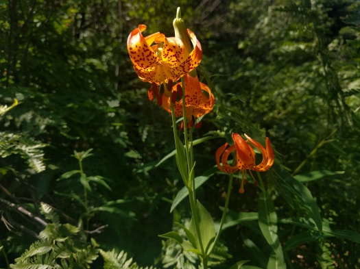
After a long, uninterrupted climb on the exposed rocks, I stopped for water at a stream around mile 1513. I was more tired than I realized, and after chugging a liter of water, I settled down on my hiking mat and promptly went to sleep. Surrounded by lilies and the gurgling sound of water, I slept for nearly two hours.
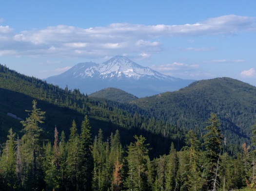
When I got back going, my head was a bit hazy, but I cleared up quickly with the strenuous climb into the ridge. As I filled up again on water at a spring rich with carnivorous plants that looked like they had dastardly handlebar moustaches, I could see back over the now-distant Castle Crags. Then, as I crossed over the ridge I got a clear view of Mt. Shasta towering over the nearby hills. It was colored purple with distance except where white streaks of snow packed its valleys. Sitting on top of it like a hat were little tufts of clouds.
For a portion of the six-mile stretch from the spring, I walked with a garralous older man named Black Cap, who was not, in fact, wearing a black cap. He was very chatty and told me all about the two bears (sometimes it was three) that he saw earlier in the day, his previous section hike along this trail, the blueberry bushes along the side of the trail, and his hometown in Roseburg, Oregon. He took a break about mile 1516 and I left him there, heading into the trees with one last glimpse of Castle Crags.
On there other side of the ridge, I had a clear view north over what seemed like endless hills and winding river valleys. Despite my clear view, this was a new area that I had plopped myself into, and I didn’t have a good sense of direction or the geography. My only constant navigational aid was the sun, which was now settling toward the horizon – and even that I lost from time to time as I ducked into thick forest.
Opposite of the sun sat Mt. Shasta, set off by two deep blue lakes just down below me that still had a bit of snow on their northern slopes. With Mt. Shasta’s size, its prominence, and the fact that the trail did a big half circle out west, then north, then back east, I figured I’d be seeing a lot of that mountain. I was reminded of Katsushika Hokusai’s series of woodblock prints, Thirty-Six Views of Mt. Fuji. Perhaps I’d have my own series by the end of the month.
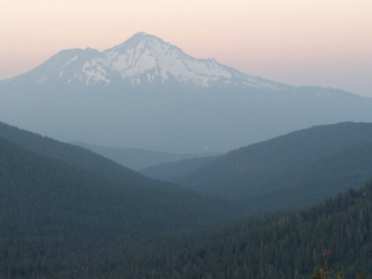
I had forgotten that the sun set so much later in the north, so I kept walking well past 8 p.m., over a saddle and leaving the lakes behind. Yet while I lost the lakes, I continued along a ridge and eventually ended up at a campsite with sweeping views of Mt. Shasta. The peak was framed in the fading light by two sloping hills on either side and it looked even more massive thanks to three white lights at its base that weakly shone through the darkness. This was my view as I ate dinner and set up camp, a hearty welcome back to the PCT.


A great first day back on the trail — the desert is interesting but the Pacific Northwest is absolutely gorgeous.
LikeLike
Oh man you are so right. I’m furiously trying to catch up on the blog so I can share some more pictures.
LikeLike
I finally can get my weekly PCT fix. Great to see you’re back on the trail!
LikeLike
Me too 🙂
It’s great to be back in action!
LikeLike